Waterfalls
Cook County has the North Shore’s most dramatic waterfalls, including Devil’s Kettle Falls in Judge C.R. Magney State Park, the ephemeral “phantom falls” that pour from the cliffs lining Highway 61, and the High Falls of the Pigeon River in Grand Portage State Park.
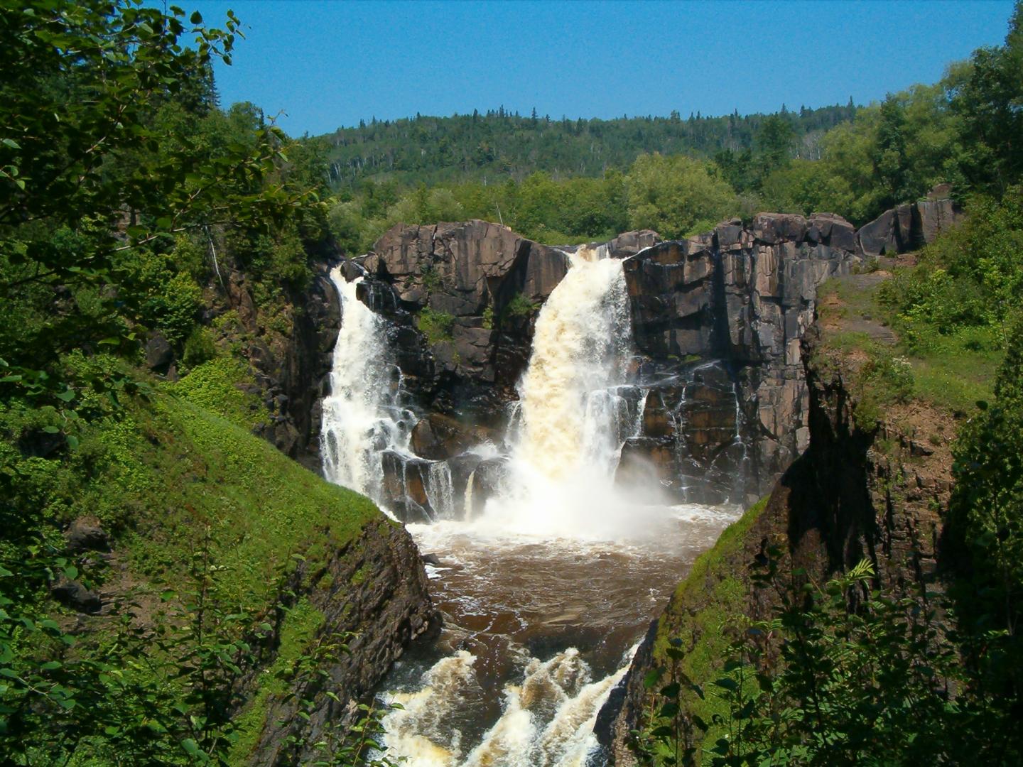
At 120 feet, High Falls (pictured above) is the highest waterfall in Minnesota. No wonder it is sometimes called “Minnesota’s Niagara.”
WATERFALL WEEKEND ROAD TRIP
Drive Highway 61 – the North Shore National Scenic Drive – from Duluth to Grand Portage for an awesome waterfall-watching adventure. The trip makes a great spring getaway for couples, families, and anyone who is looking to get outside.
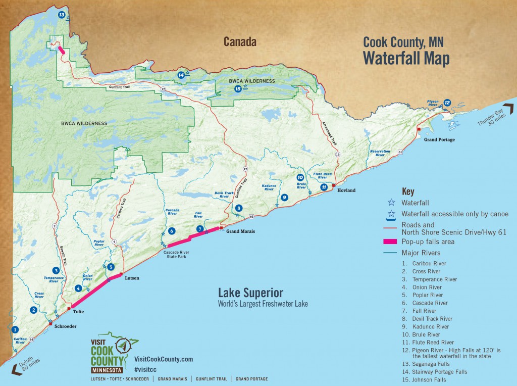
(NOTE, there are more waterfalls in Cook County than what is listed on the map. Happy waterfall hunting!)
- Caribou River – a short gradual climb along the river will bring you to the spur trail to the Superior Hiking Trail to the base of the waterfall. Park at Caribou State Wayside rest; off of Highway 61 |> GPS [47.464124, -91.030941]
- Cross River – Best falls seen right from the highway at the wayside rest in Schroeder. Just eight miles north of the county line, you will find easy access and parking. Bring a raincoat. The view from the bridge on scenic Highway 61 is one of the best, and the spray might ruin your hair. |> GPS [47.544289, -90.896796]
- Temperance River – in Temperance River State Park there is a short hiking trail loop that will bring you around the falls.|>GPS [47.554542, -90.874481]
- Onion River – newly reconstructed trail from Highway 61 will bring you along the river for a canyon view. Legend has it that the river was created and named when Paul Bunyan shed tears while cutting the wild onions that grew in the woods nearby. Park at the Ray Berglund Memorial Wayside Rest right off of Highway 61 between Tofte and Lutsen.
- Poplar River – located in Lutsen. Hike inland to roaring fall, cascades and canyons. You’ll find multiple waterfalls and rapids that are easily accessible from multiple locations.
- Upper Falls above Lutsen Mountains Ski Hill – park at the end of Ski Hill Road at the start of the connector trail for the Superior Hiking Trail. Stay to the left on the trail and follow the old road down to the bridge about a half-mile walk.
- Rapids – run through the Superior National Golf Course both the River and Canyon course. Request permission from the Golf Shop and stay on the cart path.
- Lower Falls at Lutsen Resort – Where Lake Superior and the river converge, find covered bridges and a small series of rapids just above the mouth of the river. Park in the lot and follow signs for the “River Trail.”
- Cascade River – A breathtaking series of large cascading waterfalls; this location includes parking and a walking path, which makes hiking along multiple waterfalls possible. The Cascade River flows from one ledge after another for a total drop of 900 feet during the last three miles to Lake Superior. |>GPS [47.707828, -90.523152].
- Thompson Falls on the Cascade River near the intersection of The Grade and Bally Creek Road.
- Hidden Falls of the Cascade River downstream from County Road 45 on the Superior Hiking Trail.
- Fall River – waterfall (just west of Grand Marais by about two miles). Spectacular waterfall below the highway that drops into Lake Superior. |>GPS [47° 44.455’ N / 90° 23.295’ W] Park along the shoulder along Highway 61.
- Devil Track River – follow the Superior Hiking Trail for a ravine view. With caution, the falls are more easily accessible by snowshoe in the winter.
- Kadunce River – Just 12.7 miles east of Grand Marais, the Kadunce has easy access, up-top viewing, with a hike on the Superior Hiking Trail. Feeling adventurous? Hike up the shallow river for a different vantage point. Parking available in the lot off of Highway 61.
- Brule River – 8 miles up the road in Judge C.R. Magney State Park you’ll meet the Brule River. Best known for the Devil’s Kettle waterfall where the river splits and half the river enters a cauldron, the Devil’s Kettle, and disappears to places unknown. Enter Judge C.R. Magney State Park to get to the parking lot. |>GPS [47.819284, -90.051704]
- Flute River – unnamed waterfall on the lake side of Highway 61. |> GPS [47.843897, -89.962582]
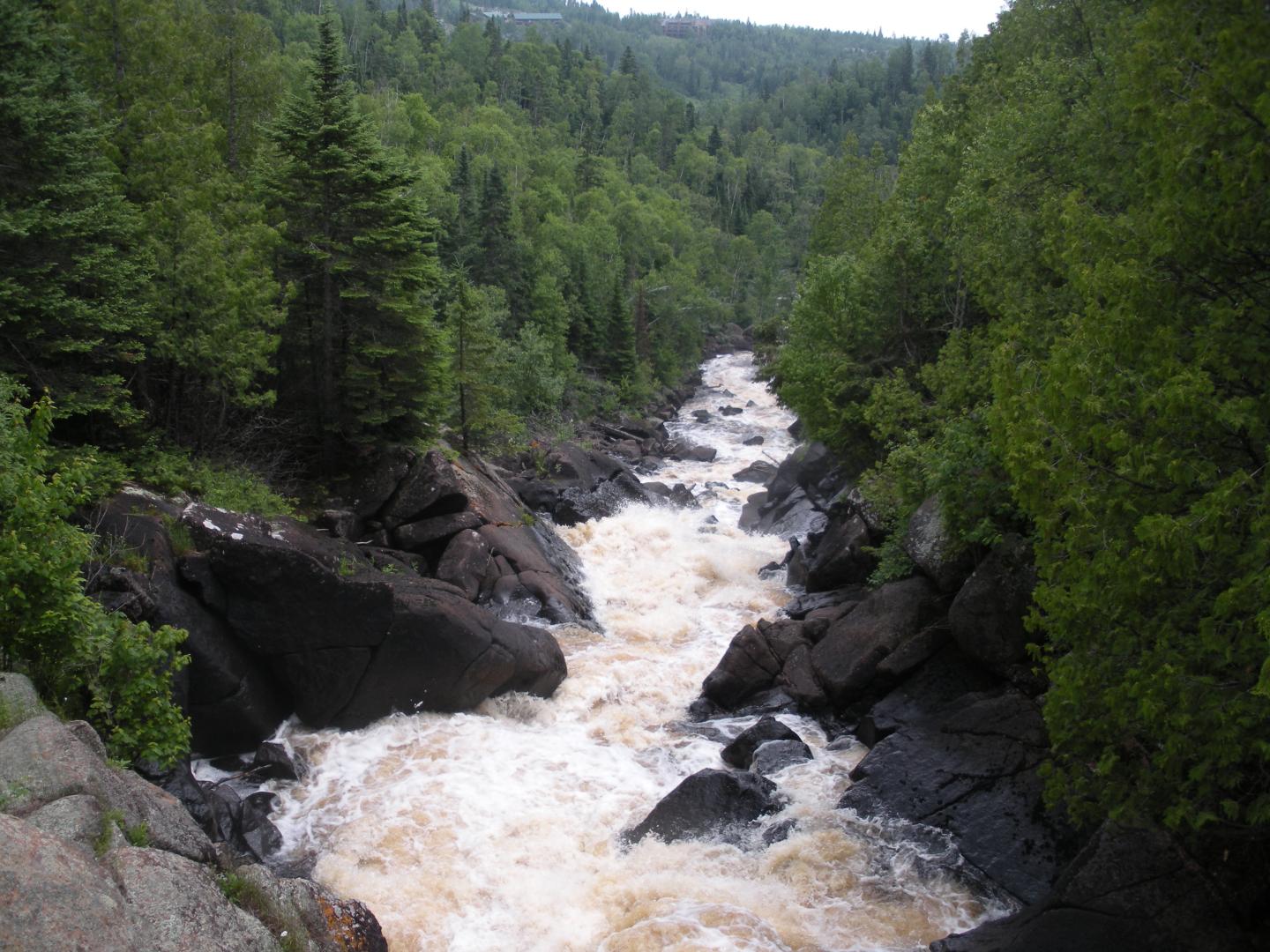
- Pigeon River – in Grand Portage State Park at 120’ the High Falls is the tallest waterfall in the state of Minnesota. Handicap accessible trail is about 1 mile long. During peak waterfall season, find a nearly permanent rainbow at the base of the High Falls. Parking is available in the Grand Portage State Park visitor center parking lot. |>GPS[48.004560, -89.597588]
- Saganaga Falls – where the Granite River and Saganaga Lake meet. Must use a canoe to reach this area.
- Stairway Portage Falls – between Duncan and Rose Lake in the Central Gunflint Trail region. Must use a canoe to reach this area.
- Johnson Falls – on the far west end of Pine Lake. Accessible from either the Gunflint Trail or Arrowhead Trail. Must use a canoe to reach this area.
Looking for more?
Make sure you pick up the only waterfall-season guidebook: Waterfalls of Minnesota’s North Shore, published by North Shore Press right in Grand Marais.
Peak waterfall season lasts about two weeks in April or May.
“NIAGARA OF THE NORTH SHORE”
At the top of the North Shore, near the Canadian border, is stunning High Falls, “the Niagara of the North Shore.” Some facts about High Falls:
- Tallest waterfall in the state (120 feet).
- Also called Pigeon Falls.
- Located at the top of the North Shore in Grand Portage State Park, just short of the Canadian border.
- About 45 minutes from Grand Marais, or just over five hours’ drive from the Twin Cities.
- The walk to the viewing area is short enough for children.
- In summer, a wooden boardwalk makes High Falls wheelchair- and stroller-accessible.
- Grand Portage State Park gets only 1/16 the crowds of Gooseberry Falls.
BIGGEST, MORE MYSTERIOUS, AND LEAST CROWDED
Cook County is home to the biggest, most mysterious and least-crowded of the North Shore’s waterfalls, including:
- High Falls of the Pigeon River, the tallest waterfall in Minnesota, which gets only 1/16 the crowds of Gooseberry Falls.
- Devil’s Kettle Falls, which flows into a mysterious (bottomless?) hole in the rock.
- “Phantom falls,” ephemeral waterfalls that pour from the cliffs that line the Cook County stretch of Highway 61.
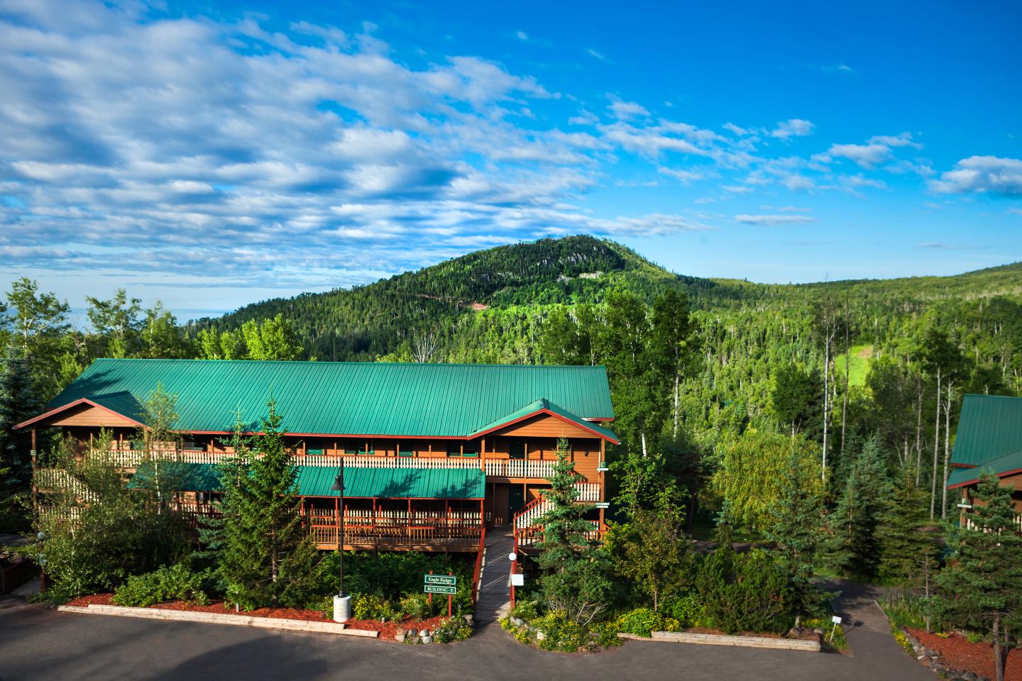
YOUR BASECAMP FOR ADVENTURE
Your Basecamp for Adventure on the slopes and in the woods! Featuring a variety of studio and condominium units, Eagle Ridge Resort is set amidst the peaceful Sawtooth Mountain where guests play by day and relax by night. Each of our units has been designed to complement the natural beauty of the surrounding Superior National Forest. All rooms overlook Moose Mountain and the Poplar River Valley.
After a day spent chasing waterfalls, retreat to the comfort, warmth, and tranquility of your home base at Eagle Ridge Resort.